Tabletop
Summary
Updated 6/22/2026 Read time: 15 min
EDITs: Incorporated NAT Doc 007 update (3/19/2026). Reykjavik removes RCL, RCL uses ETO vs ETA. Greenland airport updates.
Part checklist, part walk-through, this tabletop exercise provides a comprehensive summary of all trip preparation and execution for a trans-Atlantic mission.
Our trip will be tailored for two operations: a PC-12 along the former Blue Spruce Routes and a G600 flying non-stop. Both operations are conducted under Part 91 regulations and will utilize Foreflight Dispatch with Active Navlog and an international trip support handler, flying from KDAL to EDDF.
This tabletop is the culmination of the 20 preceding articles. The links below will take you to more information or directly to the source.

Details
Aircraft Documents
Airworthiness Certificate: Correct N-number
Registration: Correct permanent registration in hand or, if a temporary registration, a Declaration of International Operations within 10 days of an international trip.
Operating Limitations: up-to-date AFM and placards.
Weight & Balance: up-to-date paperwork and matches FMS & W&B software
Pilot Docs
Pilot license: typed, current, & instrument rating
Medical: appropriate for operation & unexpired (to the date, not to the end of the month)
Passport: 6 months validity left recommended
Visas/ Travel Authorizations as required (UK GAR)
Vaccinations as required
Company Letter authorizing crew members
Operational Preparation
Aircraft greater than 75,000lbs MGTOW: Register as an EASA Environmental Portal User and submit aircraft noise documentation.
Insurance Coverage: crew and territory requirements met
AIPs/Jeppesen Airway Manuals: available via Foreflight Docs, reviewed for country and airport specifics.
Aircraft Equipment: understanding route and altitude limitations
PC-12:
Single LRNU
VHF radios
8.33 VHF spacing
ADS-B Out
G600:
Dual LRNU
8.33 VHF spacing
CPDLC (FANS 1/A RCP240 & ATN)
Dual HF radios
SELCAL
ADS-B Out
ADS-C (RSP180)
ICAO Flight Plans: coded and filed correctly
General Declarations
Authorizations
PC-12: Domestic RVSM (no LOA required), MEL
G600 LOAs:
A056 Datalink
B036 RNP 2/4/10
B039 NAT HLA
B046 RVSM
C052 GPS Approaches
G600 Registrations:
SMS Manual: MGTOW > 12,500lbs
Overflight Permit: not required unless entering the US from the South
Visa Waiver Program: If you plan to fly foreign nationals into the country (and didn't fly them out of the country first), you need to be a Signatory Carrier
International Procedures Training
Some Options:
Gear
Medical kit, flashlight, & …
PC-12: A ton for a single engine aircraft. For this exercise, you plan to rent a life raft and immersion suits via Far North Aviation.
G600: Life Rafts, life vests, PLBs, signaling devices
2nd pair of eyeglasses for crew, if you use corrective lenses
International iPad/Phone Chargers
Local currency cash
Data/ Software
Navigation data and charts for trip
eAPIS account: Foreflight and/or ITS Handler
iPad/Phone international data subscriptions
Resources/ Contacts
Handlers: International Trip Support (ITS) handler account setup
Contract Fuel account setup. Some options:
Medical/ Security, an option: MedAire
International Credit card authorizations
ETS/CORSIA registration: MGTOW > 12,500lbs. Some options:
With the documents in place, accounts set up, and gear purchased, you can turn your attention to the trip—first, the PC-12 and then the G600 operation. The G600 is obviously the better tool for the job; however, even the G600 is only a few MEL'd items away from route and altitude restrictions or procedures applicable to small aircraft.

PC-12
Trip Preparation
First of all, you've decided that conducting a trans-Atlantic mission is an acceptable level of risk for you. Then you've watched the weather over the Atlantic. You plan for success by timing your crossing with favorable weather conditions, ideally avoiding weekends or holidays. For optimal conditions, summer is preferable for both icing and daylight. You've considered routes:
CYYR - BIRK: pushes range, fewer stops
CYYR - BGQO - BIRK: need good weather in Greenland (Note: BGQO now open and BGBW closed as of Spring 2026)
CYFB - BIRK: slightly shorter, better VHF communication and surveillance coverage.
CYFB - BGSF - BIRK: best for range limited ops
BIRK vs. BIKF: Reykjavik is better for food, beer (LINK), stays, and culture if you can manage a wet 5100 ft runway. Keflavik is better for tech stops.
Due to a forecast high-pressure system South of Greenland, you anticipate good weather and tailwind. You communicate with your ITS handler the following itinerary:
Day 1: KDAL - KBGR
Day 2: KBGR - CYYR - BIRK
Day 3: BIRK - EGPC - EDDF
As a cost-conscious operator, you plan your flights from KDAL to KGBR to CYYR, including eAPIS (filed via Foreflight Dispatch). You (the PIC) also called CANPASS on Day 1 to notify the Canadian Border Patrol of your tech stop and have arranged contract fuel for both KBGR and CYYR. Looking ahead, your ITS handler collaborates with local Icelandic handlers to arrange customs and immigration for your overnight stay. You and your passengers have already submitted the UK GAR advance notification and completed a UK ETA. Your ITS/local handlers are confirming arrival details with Frankfurt customs and arranging a landing slot. A review on Customs here. Your ITS handler has arranged contract fuel releases and any catering you desire and has loaded the flights into your Foreflight Dispatch account.
Departure
Day 1 is a leisurely 5.5-hour domestic flight to the Northeast. Taking advantage of your domestic ADS-B RVSM exemption, fuel is no issue at FL290. You top off and enjoy a steak dinner. The ITS will send a preliminary flight plan for your two legs tomorrow.
Day 2, Leg 1: 6 am show, 7 am departure from KBGR, 2.5 hours, landing CYYR at 10:30 am local. Your ITS briefing packages arrive early for both legs. As you cross the border into Canada, you are no longer RVSM qualified (your flight plan codes should reflect this). Ops are familiar with Canada. You taxi into the FBO, and before opening the door, you call CANPASS again to report your arrival. Customs pulls planeside, checks passports, sweeps the aircraft, and le bill is processed via the FBO. You've also elected to rent a life raft and immersion suits from Far North Aviation and load them up. One premixed Jet-A top-off quick-turn later, you're ready for an oceanic leg.
Oceanic Ops
Day 2, Leg 2: 11:30 am departure, 5-hour flight, landing BIRK 19:30 local (also Zulu). Lucky you, you have some tailwind, and you elect to skip a Greenland tech stop.
For a refresher on oceanic operations, review North Atlantic Overview, Goodbye Blue Spruce Routes, and NAT Operations. Now it's time to whip out your Oceanic crossing documents, which are mostly digital. We will focus on a crossing utilizing Foreflight Active Navlog vs. paper. For a rundown of paper procedures, go back to the Master Document article.
Master Doc: Foreflight Active NavLog
Foreflight Trip Briefing:
Navigation Log: PRINT
NOTAMs
Weather: Airports, SIG WX charts, PIREPS, Space wx
Oceanic Track Messages
ETPs (Equal Time Points): CYYR - BGQO and BGQO- BIKF
Volcanic Ash Information
ICAO Flight Plan
RAIM Check
Communication Log (voice position reports): PRINT
Oceanic Checklist: PRINT or use a Foreflight electronic version
Contingency Procedures (Courtesy Ops Group)
Jeppesen North Atlantic Plotting Chart (Backup to Foreflight map)
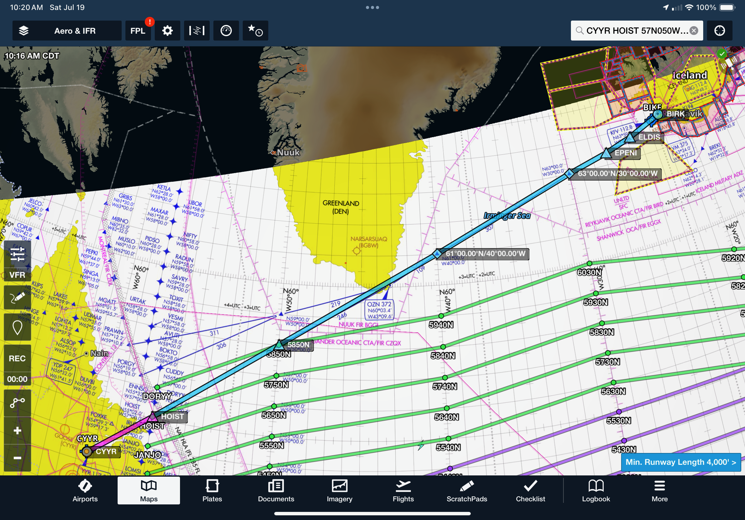
Your filed flight plan is:
Route: CYYR - HOIST - 57N050W - 61N040W - 63N030W - EPENI - ELDIS - BIRK
Altitude: FL270
Speed: 265 knots
Goosebay Clearance Delivery throws you a re-route of 58N050W instead of 57N050W, and you update your Foreflight Flight accordingly. The FBO prints a fresh Navlog as a backup. Armed with a Communication log (Print and use if unfamiliar with voice position reports) and an Oceanic Checklist (Printed version for PC-12, and we will use a Foreflight Checklist for the G600), you're ready for action.
Once you have your clearance, activate Active Navlog in Foreflight. Active Navlog is your Master Doc, plotting chart, and ETP info rolled into one. You can record your clearance, position check, and altimeter check all in the Active Navlog. Your Foreflight Briefing contains track messages, weather analysis, and all the other documents mentioned above.
Turning to your aircraft, note your master clock (FMS 1 time), check the present position, check (and record) altimeters, and verify databases. One pilot loads your flight into the FMS, checking waypoints, expanded lat/long coordinates, and course/distance info. The other pilot independently verifies all entries, starts non-radar procedures in the Active Navlog, and circles each non-radar waypoint as it is confirmed.
Takeoff to OEP
Taxi, takeoff, and departure are the same. Before reaching the OEP, HOIST, Gander Domestic will ask for an ETO (Estimated Time Over Significant Point - no longer ETA) to the OEP (+- 2 min), Flight Level, and speed.
You: "N12345, HOIST at 1315z, FL270, 265 knots, negative HF."
Gander Center: "N12345, at HOIST contact Gandar Radio, Primary 133.425, Secondary 127.675."
Record the details on your Communication log. The communication log can be prefilled with the non-radar waypoints in advance.
OEP
Over HOIST, you record your flight details within Active Navlog: time, fuel, altitude, winds, temp, notes, and put a slash through HOIST. You start your GNE timer, record an altimeter check, and finally call Gandar Radio on 133.425:
You: "Gander Radio, N12345 on 133.425, Position."
Gander Radio: "N12345, Go ahead."
This is where the communication log shines. You already prefilled it with the waypoints, and if you add the other details, the comm log becomes your script for talking with Gander. Your estimated time should be +-2 min. If it changes by 3 minutes or more, advise Gander.
You: "Gander Radio, N12345 crossed HOIST, Time 1315z, FL270, Estimating 58N050W at 1415Z, Next 61N040W."
Gander Radio will give you another set of primary and secondary frequencies and instructions to contact radio again over the following waypoint. In this case, it's still Gander Radio over 58N050W.
Gander Radio: "N12345, call Gandar Radio over 58N050W, Primary 133.425, Secondary 127.675."
Cruise
Now you are in oceanic airspace, and you may SLOP up to 2.0 nm right of course by 10ths (1.2 nm or 1.8 nm, for example). Ten minutes after crossing HOIST, squawk 2000 and complete your GNE check within Active Navlog. Add a second slash through HOIST.
Now you monitor. As you approach waypoints, ensure the next one is correct and that it sequences properly. Record the data on crossing and complete a position report, as well as GNE checks. Monitor your latitude and longitude via the map in Active Navlog to determine your position relative to ETPs in case the need arises to divert.
Over 040W, complete another position report. Gander will give you new frequencies for Icelandic Radio to report to over 030W. Remove any SLOP before 030W, as this is the edge of Reykjavik's CTA, and expect to receive a Reykjavik Control frequency from Icelandic Radio. Reykjavik will give you a squawk, and it's back to the radar environment and normal PANS OPS to landing.
The weather is marginal VFR in Iceland on a good day; expect an approach on arrival. After landing, record your times, fuel, and altimeter check, and sign the Nactive Navlog to close it out. Retain for at least 6 months.
Passports stamped, luggage scanned, international trash disposed of, Jet-A mixed with Prist at the nozzle, and you're ready to call it a night. Note that some chart databases only extend as far as Iceland and may need to be updated for Europe tomorrow.
UK
Day 3, Leg 1: 0800 departure, 2.5 hour leg, landing EGPC at 1000 local. We need to drop the rental raft and immersion suits in Wick. Otherwise, we could have planned to go to Germany.
Your ITS handler sends the flight plans the morning of departure for your review:
Route: BIRK - LUTER - MOXAL - RATSU - DEVBI - BAMRA - EGPC
Altitude: FL270
Speed: 265 knots
ETPs: BIHN - EGPC

Even though it's an oceanic leg, this one will seem like domestic operations. Complete an Active Navlog for the leg, just as you did yesterday. Request a startup clearance. Normal taxi through takeoff. On the way to MOXAL, Reykjavik gives you direct RATSU, and you're in surveillance coverage the whole way. RATSU is on the edge of and avoids Shannon's airspace, which requires HF radios to fly in. Update your Active Navlog with the direct routing and record the info over RATSU. You will be handed off to Scottish control.
Approaching Wick, ATC asks what surveillance services you want. Your answer: "deconflicting." Now, you're paying them to separate you from other aircraft. On landing, you complete and sign your Active Navlog. Customs checks passports. Since you've already completed the UK GAR and ETS and are only tech-stopping for fuel, everything is in order, and you're on your way. The life raft and immersion suits are offloaded, and fuel is uploaded.
Europe
Day 3, Leg 2: 11:00 am local departure, 3 hours enroute, landing EDDF 16:00 local.
Final leg. Fatigue is setting in. Your ITS handler has generated a Eurocontrol Validated flight plan, and the EDDF landing slot ID is correctly added to the Remarks, Box 18, on your ICAO flight plan.
Route: EGPC WCK SMOKI NANEV ADN P18 OKPAL BALID P18 NEXUS GOMOT BEVAM NAVEL OTLAB LARDI L74 MONIL P62 PAM Z739 MISGO T911 ROLIS ROLIS5D EDDF
Altitude: FL230

In all, about 50 waypoints for a relatively short flight. Without an RVSM LOA, you're limited to FL280. Ditto if you don't have ATN CPDLC (unless you are exempt from the requirement).
Flying the aircraft is the easy and familiar part. Heading, course, altitude. On departure, you're handed off to Scottish control and they give you direct to the edge of their airspace. Radios provide the challenge. With all the slight differences in instructions, additional frequency digits, and wildly varying accents you encounter, all while operating below your max capacity, it takes focus. Be prepared for control to direct you to an unfamiliar waypoint. Despite the lengthy flight plan, shortcuts are common.
Scottish - London - Amsterdam - Maastricht - Langen - Frankfurt Arrival - Frankfurt Radar - Tower - Ground
On arrival, you're given "Direct DF443," a GPS waypoint on the approach procedure (yes, they use numbers). You conduct a CDFA ILS approach, taxi in, and complete your Master Document by recording your final data points in the Active Navlog, sign it, and it's autosaved in Foreflight.
You are met rampside by your local handler. They escort you into the facilities, where your passport is checked, declarations are made (if required), and your luggage is scanned. Past customs and immigration is the shared lobby of all the local handlers (don't expect a stand-alone FBO facility). Have a cappuccino while they prepare your bill.
Three days, five legs, seven time zones, 18.5 flight hours, and 4,800 nautical miles later, you made it. You've earned that German pilsner and accomplished a journey and adventure few have taken.

Photo courtesy of Colin Waldorf.
G600
Trip Preparation
All the above prerequisites are complete. You plan a daytime crossing, departing in the morning and arriving in the evening: One leg, 9 hours, departing 0600, landing 2200 local. Utilizing an ITS handler and Foreflight Dispatch/ Active Navlog, your flight is planned as follows:
Route: EMMTT4 BSKAT HUMBO J131 PXV KLYNE Q29 JHW Q84 CAM Q822 ALLEX NOTOP Q806 PERLU NICSO 48N050W 50N040W 52N030W 53N020W NEBIN OLGON MORAG FACTU P155 SIVDA P137 REDFA DIXAT DIXAT1D
Altitude: FL410 initially, FL450 over the Atlantic (above the NAT HLA and tracks).
Mach: 0.87
ETPs: CYQX - EINN
Fuel: 34,000 lbs, and meets ICAO/EASA fuel requirements.
Alternate: EDFH with route, altitude, and fuel burn calculated.
Flight plan: filed 3 hours in advance, and EDDF slot IDs are in the remarks section.
Departure
Your ITS files an outbound eAPIS, has arranged a fuel release, ground services, and arrival customs at EDDF. Before departure, you log on to KUSA for a DCL via CPDLC and are cleared as filed.
Armed with the following Oceanic Documents, you are ready to program the FMS, independently verify all waypoints, and launch.
Master Doc: Foreflight Active NavLog
Foreflight Trip Briefing:
Navigation Log
NOTAMs
Weather: Airports, SIG WX charts, PIREPS, Space wx
Oceanic Track Messages with TMI number
ETPs (Equal Time Points): CYQX - EINN
Volcanic Ash Information
ICAO Flight Plan
RAIM check
Oceanic Checklist: Foreflight electronic version
Contingency Procedures (Courtesy Ops Group)
Jeppesen North Atlantic Plotting Chart (Backup to Foreflight map)
Takeoff to OEP
As you climb through 16,000ft, you verify you are logged on to KUSA. CPDLC communications are established shortly thereafter, and you utilize Domestic CPDLC through US airspace. As you approach the Canadian Domestic Airspace CPDLC area, the CPDLC logon is automatically transferred to Moncton ACC.
At a prescribed window before your OEP, you send an RCL message via ACARS. In this case, it's Gander (CDQX), 60-90 minutes before NICSO (your OEP). See the chart for the other RCL windows. An RCL message used to mean 'Request Clearance.' Now, you already have your clearance on the ground at KDAL (except for Shanwick, who still gives an RCL clearance). Your RCL message is now what you want to do, your request, not your clearance.
RCL Fields: CYDX, FL450, M0.87, NICSO, 1600Z, Free text: Max FL470
Gander acknowledges receipt of RCL via CPDLC. Expect no further communication about it unless there is a route change. Note, until the end of 2025, Gander will only issue route changes via voice.
As you approach the OEP, Gander Domestic gives you a VHF frequency to contact Gander Radio. After contact, Gander Radio gives you a Gander Radio HF frequency. You call Gander Radio on HF:
You: "Gander Radio, N12345 on 8825, SELCAL check, Shanwick next."
Gander Radio: "N12345, Gander Radio, Standby SELCAL, Primary 8825, Secondary 11309." -SELCAL tone emits -
You: "N12345, SELCAL checks okay, Primary 8825, Secondary 11309."
OEP
Over NISCO, you complete the Active Navlog fields and start your GNE timer. You receive two CPDLC messages: one to set the maximum uplink to 300 seconds, and a second to confirm assigned route. Your response is to verify/set 300 seconds and to send a verification message via CPDLC. You SLOP a random distance right of course, say 1.9 nm, and monitor 121.5/123.45. 10 minutes after NISCO, complete the GNE check via Active Navlog and set squawk 2000.
Cruise
At 48N050W and 50N040W, you record your waypoint crossing data, conduct hourly altimeter checks, and complete 10-minute GNE checks.
Contengencies
Looks like thunderstorms ahead. You contact Gander via CPDLC and request a 20 nm offset right till 50N040W due to weather. Ask and you will receive, if able. Let's say you don't receive a response, so you try via voice on HF. Still nothing, and those storms are quickly coming. Now it's time for the weather deviation contingency.
You begin to deviate right, turning off course by 30 degrees. Within 5 nm, you stay at your assigned altitude, in this case, FL450. Greater than 5nm, you SAND: South of track, Ascend, North of track, Descend by 300 ft. For your eastbound flight, right deviation, you ascend to FL453 from 5 nm to 20 nm off course. Past the weather, you return to track, making sure to be back at FL450 by 5 nm of your course.
Back on course, and things are going well again. BANG, rapid decompression. Now, ideally, you would get a revised clearance before deviating from your given clearance, but in the case you cannot or your situation requires immediate action (like this one), you proceed with the oceanic contingency:
Turn off course 30 degrees and maintain altitude until 5 nm off course. From here, the procedure becomes situation-specific. If you are flying a track for random route overlaying a track, this works great. If your random route crosses tracks, look to offset from the tracks if you plan to descend through them.
If you plan to stay at altitude, such as due to equipment degradation that limits speed, offset your altitude by 500 ft (if at FL410 or below) or 1000 ft (if above FL410). In our depression scenario, you're descending. Once 5 nm offset, commence an emergency descent to below FL290. Once below FL290, you are under the NAT HLA, and traffic drops off considerably. Attempt to obtain clearance for a route change; if you are unable to do so, you may begin your diversion.
Reviewing your ETPs, you determine that you have not yet crossed your depressurization scenario ETP and receive a revised clearance direct to CYQX.

Curtesy Ops Group
Back on Course - OXP
Rewind the tape, we're back in cruise like nothing happened. As you approach 52N030W, Gander sends a CPDLC message to contact Shanwick Radio on 8831 over 30W. The process is the same as contacting Gander earlier: call, SELCAL check, primary and secondary frequencies, max uplink, and assigned route CPDLC messages.
Approaching your oceanic exit point (NEBIN), Shanwick sends a CPDLC message to contact Shannon on VHF and gives you a Squawk code. You remove any SLOP before NEBIN and call Shannon with Squawk and altitude. You're back to radar procedures. After recording the details in the Active Navlog, you end non-radar procedures.
Europe
Almost there. Within Eurocontrol airspace, you lookup the ATN CPDLC login. In this case, Shannon (EISN). Operations are similar to Domestic CPDLC ops. CPDLC handoffs between ACCs are mostly automatic; however, verify that they are correct as you cross into London, Amsterdam, and Rhein control areas.
Same ops into EDDF as the PC12. On the ramp, don't forget to record your landing and block in data, complete a ramp position and altimeter check, complete the Active NavLog with a signature, and retain for 6 months.
One day, one leg, seven time zones, 9 flight hours, and 4,500 nautical miles later, you made it. You've still earned that German pilsner.
P.S.
This article concludes our international journey (minus a Bonus QFE article Next). I have never been stretched more as a pilot than when doing these crossings and flying around Europe. It's a challenge and adventure. I've been fortunate to have the opportunity and recommend the experience.
When first presented with the prospect of an Atlantic crossing mission, I was in over my head. I hope this guide will help you get your bearings, be prepared, and execute your mission safely.
If you have found this information helpful or notice any mistakes or misinformation, please let me know. Thanks for reading.
- Tailwinds
Navigate
Article 21 of 22 on your international operations journey. Eject at any time to land at international articles.